AARP Hearing Center
The transformations presented here — and included in The Imagining Livability Design Collection — show real locations as they appeared during visits by AARP Livable Communities and the WALC Institute between 2010 and 2015. WALC helped each community develop a vision for the future, and it created photovisions to reflect those changes and how each place could be made better.
1. Inspiring Redevelopment
KINGSPORT, TENNESSEE
This corner on the edge of the downtown provides great potential for an underperforming area that’s dominated by a dusty parking lot and strip-format buildings. Across one street, the city has constructed a multiuse path that will connect to a “greenbelt” trail for walking and bicycling. Nearby, a new building houses medical offices and the Chamber of Commerce.
The Challenges
- Although this is an underperforming area, nearby development creates a demand for services and people are frequently seen crossing midblock.
- The intersection is somewhat chaotic, with drivers "shooting the gap" to make left turns and with two legs of the intersection lacking crosswalk markings.
- The road is overbuilt for cars and is a great candidate for a road diet.


The Possibilities
- The street is retrofit to be more supportive of people and a mix of land uses makes it a premier destination.
- Greater density and multistory buildings are allowed.
- Blocks are about 300 feet long and rows of buildings front the streets, creating an interior courtyard within them.
- On-street parking reduces the need for off-street parking, which simultaneously improves walking conditions by helping to calm traffic and to create a buffer between vehicles and pedestrians.
- Any new off-street parking is placed behind the buildings.
- Where existing parking lots meet the sidewalk or street, they are given "edges," such as attractive landscaping, transparent fences or low walls.
- A modern roundabout moves vehicles safely and more efficiently while also making crossings easier and safer for pedestrians.


2. Making Downtown a Destination
AVONDALE ESTATES, GEORGIA
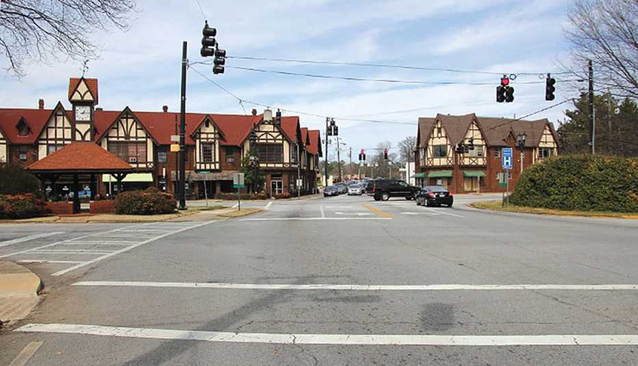
A strong sense of place and identity is created in Avondale Estates through its unique architecture, including many Tudor-style buildings. The central business district certainly benefits from these attractive buildings, as well as from on-street parking that sends the visual cue for drivers to slow down. Unfortunately, the downtown area has become a place for residents and visitors to pass through rather than stay.
The Challenges
- The posted speed limit and actual vehicle speeds are too fast for a place that should be focused on people, not just on cars.
- The intersection is complex, with many potential points of conflict.
- Pedestrian crossings are missing.
- Street corners have overly wide "turning radii.”
- The area lacks street furniture and other amenities such as bicycle racks, landscaping, wayfinding signage, and trash and recycling bins.

The Possibilities
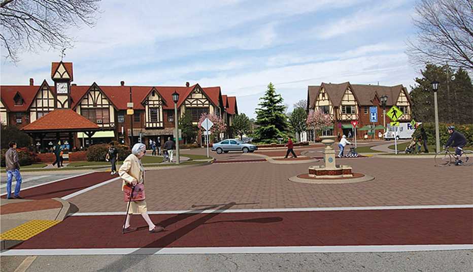
- A sense of arrival is enhanced by converting the intersection to a modern roundabout with a mini roundabout preceding it. (This combination of tools slows cars while keeping traffic flowing. It also reduces noise and makes it easier to get into and out of a parking spot.)
- The increased quiet makes the area more suitable for outdoor dining.
- Large vehicles can make turns without encroaching on the corners.
- A colored surface is added to the intersection to further calm traffic and reinforce the community’s character and identity.
- Overhead wires are removed.

3. Revitalizing Main Street
BATESVILLE, ARKANSAS
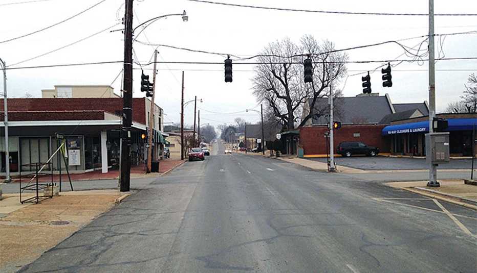
About 50 years ago, a one-way street system was imposed in Bateville's Main Street area, forcing traffic on one street to head in one direction and the vehicles going the other way to do so on another street.
The resulting fast-moving traffic, combined with a lack of investment in the downtown core, set the stage for the street to languish. Occupancy rates dropped to 50 percent, and many of the remaining businesses opened for only limited hours. A beautiful stream that flows parallel to Main Street wasn't maximized as an asset.
More recently, the community adopted a plan that envisions a walking trail along the stream. Also, a citywide effort was initiated to build parks, trails, recreational opportunities and community events. These successes, combined with a compact street grid, attractive commercial buildings and strong community and political support prime Main Street Batesville for a revitalization success.
The Challenges
- As is true of many communities throughout the United States, streets are focused on emptying the downtown of its occupants as quickly as possible. (A downtown's after-hours life, retail sales, social capital and overall sense of place suffer as a result.)
- With a 40-foot-wide roadway, drivers accelerate to 30 mph or more between signals and abruptly stop for red lights.
- The location is unwelcoming for pedestrians and cyclists.

The Possibilities
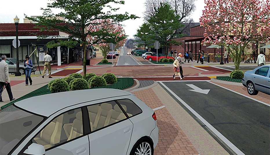
- With the goals of revitalizing Main Street and better connecting people to the nearby stream, the street is traffic-calmed and the environment made to fully support people walking and bicycling.
- The street is narrowed to one 10-foot vehicle travel lane and the remaining pavement is reallocated: 17 feet for diagonal parking spots, 8 feet for parallel parking spots and 2.5-foot buffers on each side of the travel lane. These changes, applied along two blocks, decrease the road’s speed to about 15 mph and increase the amount of available street parking from 40 spots to 65.
- Removing the traffic signal saves the city $15,000 to $30,000 per year in operation costs. Curb extensions narrow the intersection, making pedestrian crossings only 14 feet across.
- Moving the diagonal parking and parallel parking from one side of the street to the other at each block shifts the vehicle travel lane about 10 feet as it goes through the intersection. This change creates a traffic-calming "chicane."
- Suburban-style "cobra head" street lights are replaced with smaller, attractive, pedestrian-scaled lamps that illuminate the sidewalks.

Editor's Note: The Imagining Livability Design Collection was published in Spring 2015 by AARP Livable Communities and the WALC (Walkable and Livable Communities) Institute. The institute has since closed shop, but the 40-page publication it helped develop remains a valuable resource for communities and local leaders.


