AARP Hearing Center
On May 30, 1914, Lassen Peak awoke from a 27,000-year sleep with a violent explosion, the first of hundreds that rocked this Northern California mountain over the course of the next year, carving out a lava-capped crater 1,000 feet across. But the biggest eruption by far came on May 22, 1915, when a tremendous plume of steam shot into the air, shattering the lava cap and sending glowing chunks of molten lava high into the sky. As they fell back onto the mountain, which was already blanketed in a record 30-foot snowfall, the hot rocks triggered an avalanche a half-mile wide that thundered into the valley, creating a mudflow of such tremendous force that it swept over hills and into more valleys beyond, burying farms and homesteads.
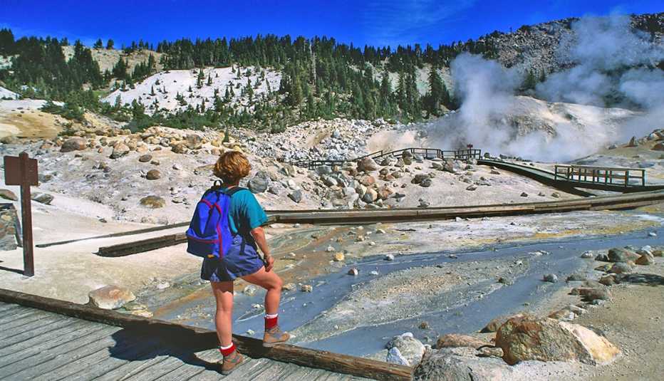
No lives were lost thanks to the early alert of the initial explosions, but more than a century later that torn and blasted landscape, known as the Devastated Area, remains. Located just northeast of Lassen Peak, it’s one of the many attractions of the 106,000-acre Lassen Volcanic National Park (LVNP), an awe-inspiring showcase for the sheer power of the Earth’s volcanic forces. The most popular attraction, Bumpass Hell — a hissing, bubbling expanse of sulfuric mud pots, hot springs and fumaroles — on the park’s southern end serves as an eerie reminder that these forces are still active today.
Four kinds of volcanoes can be found in the world: cinder cone, composite, plug dome and shield, and LVNP has all four, along with chiseled rock spires, lava fields and huge boulders tossed about like bowling balls by the formative explosions of 1914 and 1915.


Facts box
Location: Northern California
Acreage: 106,000
Highest point: Lassen Peak, at 10,457 feet
Lowest point: Hot Springs Creek, at 5,275 feet
Miles of trails: 150
Main attractions: Bumpass Hell, the Devastated Area, Lassen Peak and other geothermal and volcanic features
Entry fee: $30
Best way to see it: By car
When to go to avoid the crowds: Late August through mid-June
This magical landscape was protected in 1907 as two separate national monuments, Lassen Peak and Cinder Cone, then Congress unified them into one national park in 1916. “The park was created to protect all these amazing volcanic features after the eruption, and ever since then people have come to see this otherworldly landscape,” says Carlo Arreglo, supervisory park ranger.“The first time I drove the park highway, my jaw just kept dropping passing these majestic mountains — there was so much to see.”
Perhaps due to its out-of-the-way location, an hour’s drive on mountainous roads off Interstate 5, LVNP receives just 500,000 visitors a year. “It’s kind of this gem that people don’t know about just three to four hours from San Francisco,” says Arreglo.
You’ll experience the eerie majesty of Lassen’s cratered landscape — and pass a series of geological wonders — as you drive the Lassen Volcanic National Park Highway, which makes a semicircle around Lassen Peak, still 10,457 feet high even after blowing its top.
To the east are three additional park sections — Butte Lake, Juniper Lake and Warner Valley— all accessed by separate roads from the northeast and southeast. Since you can’t reach these areas from the park highway, check maps beforehand to determine your route if you plan to visit them.


Plan your trip
Two entrance stations, at the park’s south and north ends, provide access to Lassen Volcanic Park Highway, which runs generally north to south, making a horseshoe bend around Lassen Peak.
Driving from San Francisco, the park is 247 miles to the north. Enter the park at the southwest gate and stop at the Kohm Yah-mah-nee Visitor Center to get oriented. Here you’ll find maps and signage explaining what’s open in the park, current trail conditions and information on ranger programming. If you’re driving from Portland, 453 miles to the north, you’ll enter at the northern entrance and continue to the Loomis Museum, where a smaller visitor center provides updates on park conditions and happenings.
Be sure to download the park app, which provides a guided audio tour of 16 stops along the park highway, almost all of which can be seen from pullouts on the road or from accessible parking areas. There’s no cell service in the park, but you can use the free Wi-Fi at the Kohm Yah-mah-nee center to download the app. If entering from the north, you must download it ahead of time as the Loomis Museum has no Wi-Fi. “If you don’t download it in advance, the last reliable cell service north of the park is in Shingletown,” notes Arreglo, referring to a small community about 17 miles west of the north entrance.
In the late summer and fall of 2021, California’s devastating Dixie Fire burned 73,240 acres within the park. In addition to leaving behind huge swaths of blackened pine forest, the fire buckled park roads and destroyed lookouts and other facilities, some still closed for repairs. Nonetheless, the average visitor doesn’t experience many significant impacts. Most damage to attractions along the park highway was repaired before the park reopened this past summer.
LVNP gets snow early and it stays late, often lingering well into June on the higher trails. Wildflowers, which begin to emerge in late May and blanket the slopes and valleys all summer, have become even more profuse since the fire.
“The park is a living laboratory for fire ecology, and it has been amazing to watch the recovery process underway, especially all the flowers coming up under the burned trees,” says Arreglo.


